
 On the Map
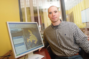
As controversy swirled around his dissertation, Sean Gorman realized his future and founded a company
If the Department of Homeland Security takes an interest in your dissertation before it is published, you can be fairly certain you chose a pertinent area of study and exploration. Sean Gorman, PhD Public Policy ’04, found himself in that position in 2004 when he was a doctoral student in Mason’s School of Public Policy (SPP) getting ready to defend and publish his dissertation, “Networks, Complexity, and Security: The Role of Policy in Critical Infrastructure Protection.”
Gorman’s dissertation demonstrated how he was able to compile publicly available information to map infrastructure in the United States. His ability to report possible breakdowns in the system raised concern. Although none of the information Gorman used to connect the dots was classified, it raised the question of where one draws the line between freedom of information and security.
“Post-9/11, there was a strong sentiment that security could be gained by obscuring, hiding, or classifying data,” says Gorman. “These issues have not gone away, and it is something the government and the public still struggle with. There are those who would like to focus on obscuring all data that reveal vulnerabilities and those who want to fix the vulnerabilities and make the nation more resilient.”
Gorman assured the Department of Homeland Security that he could publish the dissertation and create a separate report with the more sensitive information. Realizing that his knowledge and the interest that it generated provided an ideal market, Gorman, along with two SPP professors, started the company FortiusOne in 2006. Fortius is Latin for “stronger.”
Based in Virginia, FortiusOne retrieves information from different databases and presents it to users on interactive maps on the Internet. FortiusOne is one of many start-up mapping companies, but one of its main clients is the Department of Homeland Security.
Although some people in government first dismissed Gorman’s early work, Gorman received a good deal of support elsewhere, including SPP. His master’s thesis had focused on where the Internet’s infrastructure was located and whether that made a difference in economic development and growth. Gorman recalls that when he came to Mason, he originally wanted to expand the scope of the study from domestic data to international data, but a month after arriving on campus, the terrorist attacks of September 11, 2001, took place.
“Those events changed the direction of the research from economic growth to the security of the infrastructure,” says Gorman. The timing of the research was useful, and many people took interest. The decision was made that the research was patentable as intellectual property and that led directly to the formation of FortiusOne.
“The support from the school, Dr. Roger Stough [Gorman’s advisor], and Dr. Kingsley Haynes [SPP dean] was incredible from the beginning. They gave me the time and resources to work on the ideas and then the assistance to go out and find funding for the research,” says Gorman. “The project itself would have never gotten off the ground without professors Laurie Schintler and Raj Kulkarni. It was always the three of us working together.”
According to Gorman, the company has expanded from security work and now incorporates many broader public policy issues and the role geographic data plays in informing the public. At the end of May 2007, FortiusOne launched GeoCommons, an atlas of data and maps to provide the public with a geographic perspective on a huge range of issues. A community of users contributes data and maps to the atlas.
Gorman’s vision for FortiusOne is for the company to play a key role in interconnecting and sharing the world’s geographic data to make people better informed about everything—ranging from their neighborhood to the world around them. He believes that many of the policy issues facing the public can be conveyed in a powerful way with maps and that GeoCommons can help facilitate that awareness.
“Security is where we got our start,” he says, “but we feel the future of the technology is in sharing information and educating the public with a variety of serious and fun data you can visualize on a map.”